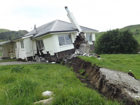
Bluff Station, Kēkerengū Valley, Kaikoura earthquake 2016. Photo credit: Courtesy GNS |

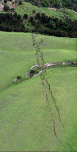
Conway near Kaikoura, Kaikoura earthquake 2016. Photo credit: SNPA |
Earthquakes can result in a range of impacts. Surface rupture along a fault can result in the displacement of the ground surface by up to several metres, both in a horizontal and vertical sense, severely damaging anything that lies across it. The displaced land may be raised, lowered or tilted and this can occur some distance from the fault line. Severe ground shaking can damage built structures, trigger landslides, and cause liquefaction.
Earthquakes have the potential for loss of life, serious injury, and significantly damage those things that we value and/or rely on for everyday living. Structural damage to buildings and infrastructural lifelines may take months or years to fully repair and some effects may even be permanent. Some of our communities, such as Murchison and Golden Bay/Mohua, could become isolated for significant periods of time should large landslides (resulting from an earthquake) block access roads. The region as a whole may be isolated following a large earthquake.
We have started work on a natural hazards plan change(external link) to the Tasman Resource Management Plan (TRMP). As part of this process, we are improving our knowledge about local hazards and sharing that information with affected landowners and communities. We have sought expert technical advice to identify active faults in our district which warrant consideration for inclusion in the TRMP.
The Tasman Resource Management Plan currently includes parts of the Waimea, Eighty-Eight, Wairau-Alpine, White Creek and Lyell faults within the ‘Fault Rupture Risk Area’ overlay as shown on our planning maps. The associated planning rules seek to avoid establishing buildings and other structures directly over these active fault lines to protect people and property. The overlay and rules act as a flag to pay extra attention when developing a site or undertaking new building work in that area and requires a geotechnical assessment to confirm the location of the fault line.
The technical advice notes that, in addition to the faults already included within the Fault Rupture Risk Area, the Whangamoa, Wakamarama and Kikiwa faults are considered active and recommends that they should also be included within the TRMP for the purpose of planning controls.
Explore the active faults in the district on the Natural Hazards map viewer.(external link)
The methodology, outputs and maps can be viewed in the following technical report:
Review of Active Earthquake Faults in the Tasman District (pdf 6.4 MB)
Other technical reports that outline the location of faults in the district are included below:
My property is located on a fault line, what does this mean?
Fault rupture can result in ground displacement and deformation at the ground surface. This can cause significant damage to structures built across or very close to the fault line.
 The Tasman Resource Management Plan includes parts of the Waimea, Eighty-Eight, Wairau-Alpine, White Creek and Lyell faults within the ‘Fault Rupture Risk Area’ overlay and the associated planning rules seek to avoid building structures directly over an active fault line. The overlay acts as a flag to pay extra attention when developing a site or undertaking new building work in that area. The Fault Rupture Risk Area rules require a geotechnical assessment to confirm the location of the fault line and that new buildings are set back from the fault line. The Fault Rupture Risk Area rules do not apply to building on property or parts of a property which are not within the mapped Risk Area.
There are several active faults – as identified in the report above – that are currently not included within the Fault Rupture Risk Area. However, the Council still considers these faults on a case-by-case basis when processing resource and building consent applications to ensure that we avoid building structures directly over active fault lines.
Ground shaking that can occur during an earthquake can also cause damage to a much wider area than identified in the Fault Rupture Risk Area. Earthquake shaking impacting buildings and structures is not directly addressed through the resource management plan. However, the Building Code requires buildings and structures to have sufficient structural strength to perform safely when earthquake shaking occurs.
How is the Council using this earthquake fault information?
Consideration of earthquake fault lines has been embedded in the Council’s work programmes for a number of years. We use this information in:
Next Steps
The next steps for the TRMP natural hazards plan change will be to engage with the community on the ‘issues and options’ for managing our natural hazards, including earthquake faults. Engagement is proposed to begin early to mid-2025 and will seek the community’s views on the options for updating the TRMP provisions that relate to natural hazards.
Landowners, iwi, stakeholders and the wider community will have further opportunities to input into the natural hazards TRMP plan change as we progress through the plan drafting stages.
Where do I find information about what to do following a natural hazard event?
Information, advice on getting prepared and what to do during a natural hazard event can be found on the Nelson Tasman Emergency Management Group website.
The Natural Hazards Commission Toka Tū Ake also has information and advice for home owners, tenants and home buyers to ensure your home is safer for natural hazards.
Last modified: