Coastal flooding can result in significant inundation of low-lying land close to the coast and is especially likely when storm conditions such as storm surges and large waves coincide with high tides. During these events, low-lying areas with direct connection to the sea can be inundated to significant depths and extent.
Coastal storm surge occurs when low-pressure weather systems affect the coast. The sea level rises in response to falling barometric pressure, and strong onshore winds and waves can pile water up against the coast. These phenomena both contribute to storm surge, that when coinciding with high tides produce higher than normal sea levels known as a storm tide. During storms breaking waves cause the average sea level to rise in the surf zone (known as wave set up), which further contributes to coastal inundation when combined with a storm surge. Breaking waves can also surge up the beach slope (wave run up) well above the prevailing sea levels and contributing to coastal flooding.
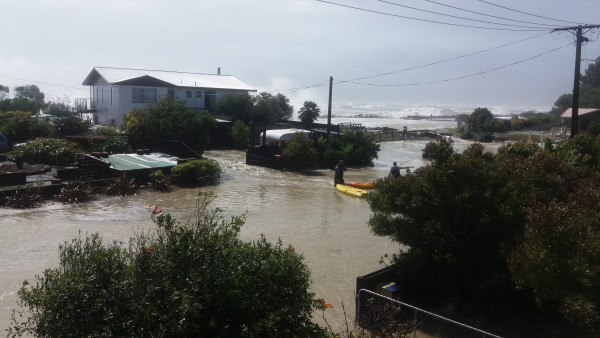
Cyclone Fehi was a significant coastal storm inundation event that affected our district on 1 February 2018. The peak of the storm surge coincided with a very high spring tide and large waves damaged the coastline, and flooded roads, reserves, nearby properties and houses. Sea level rise will increase the exposure of our coastal land to these type of events, with coastal hazards beginning to impact areas that have not previously been exposed.
The Ministry for the Environment has developed a series of factsheets which provide further information on the different elements of coastal processes. View the factsheets on the Ministry for the Environment website(external link).

Coastal flooding at Māpua and Ruby Bay from ex-tropical Cyclone Fehi (Feb 2018)
Since 2004, relative sea level rise at the region’s three tides gauges at Port Nelson, Little Kaiteriteri and Tarakohe was 0.14 - 0.15m (NIWA 2023).
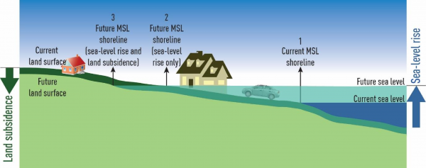
Relative sea level rise is made up of two components - a rise in mean sea level and vertical land movement (VLM). Generally VLM along most of Tasman’s coastline is subsiding (NZSeaRise 2024) which results in a higher sea level in relation to the land. Mean sea level is also rising. The combination of the increase in mean sea level together with the VLM is referred to as relative sea level rise.
Diagram: Difference in mean sea level shoreline between absolute and local (relative)sea level rise where land subsidence occurs.

Source: Ministry for the Environment. 2022. Interim guidance on the use of new sea-level rise projections. Wellington: Ministry for the Environment
The rate and magnitude of future sea level rise is uncertain, especially later this century and beyond. Scientists advise that sea levels will continue to rise and that levels are likely to rise at an accelerated rate over time as the earth’s temperature rises, meaning changes could happen sooner than predicted – or there may be changes to emission rates that reduce the rate of warming. Uncertainty is a key message. What we do know is that rising sea levels will have increasing implications for development and infrastructure in coastal areas along with environmental, cultural and societal effects.
The NZ SeaRise: Te Tai Pari O Aotearoa programme developed an online platform which presents location specific sea-level rise projections (including VLM) out to the year 2300 for every 2km of the coast of Aotearoa New Zealand. The platform outlines when specific sea level rise increments (in metres above 1995-2014 baseline) could be reached for various projection scenarios of sea level rise for New Zealand, including specific data for Tasman. For example, in Tasman we may expect up to 1.66m or 1.67m sea level rise in our district by the year 2130 (under SSP5-8.5 H+ scenario).
We have started work on a natural hazards plan change(external link) to the Tasman Resource Management Plan (TRMP). As part of the process, we are improving our knowledge about local hazards and sharing that information with affected landowners and communities.
We’ve developed a natural hazards map viewer which illustrates the extent of low-lying coastal land in Tasman Bay and Golden Bay that may be affected by a range of hazards as a result of rising sea levels. Our mapped sea level rise elevations information is based on the Ministry for the Environment’s Coastal Hazards and Climate Change Guidance (2024).(external link)
The coastal hazards map identifies low-lying land that may be impacted for a range of sea level rise scenarios in 0.5m increments up to 2m. It also shows the impacts of sea levels being further elevated from a storm-tide event with a 1% joint probability AEP (annual exceedance probability). A 1% AEP event has a 1% chance of occurring in any year.
The methodology used to develop the coastal hazards information shown on the map viewer is described in the accompanying report:
Coastal Hazards Assessment in Tasman Bay/Te Tai o Aorere and Golden Bay/Mohua (2019) (pdf 2 MB)
My property is shown within a low-lying coastal area potentially susceptible to coastal flooding, what does this mean?
In July 2019, we wrote to all landowners and long-term land occupiers to let them know if their property was included in the extent of the mapping. For some properties, the house was not included in the map, only part of the driveway, or a small area of garden or land. As a landowner, you do not have to take any action as a result of receiving this information.
The rate and magnitude of future sea level rise is uncertain, especially later this century and beyond. Scientists advise that sea levels will continue to rise and that levels are likely to rise at an accelerated rate over time as the earth’s temperature rises, meaning changes could happen sooner than predicted – or there may be changes to emission rates that reduce the rate of warming. Uncertainty is a key message. What we do know is that rising sea levels will have increasing implications for development and infrastructure in coastal areas along with environmental, cultural and societal effects.
Why is my property shown as being flooded when it’s not directly connected to the coast?
The maps simply show land at or below the elevation of the particular scenario being viewed.
The actual extent of the land flooded will be dependent on its connectivity and distance to the coast.
Low-lying land not directly connected to the coast may appear on the maps due to its low elevation but may not be subject to seawater flooding.
These low-lying areas may be subject to stormwater, river flooding and/or elevated groundwater levels that may become more prevalent as sea levels rise.
Can I subdivide or build if my property is shown in a low-lying coastal area potentially susceptible to coastal flooding?
Subdivision requires a resource consent. All natural hazards, including coastal flooding and sea level rise, are already taken into account when considering an application to subdivide land under the requirements of the Resource Management Act 1991.
When you apply for a Building Consent, coastal flooding and longer-term sea level rise at the site and the property’s exposure to natural hazards are taken into consideration through the Building Act requirements.
How will this mapped information affect my property value?
Implications of the mapped information will vary from site to site and we’re not able to determine whether there will be any effect on property values.
How will this mapped information affect my property insurance?
In the first instance you can contact your insurance provider to discuss your specific policy.
The Council cannot advise property owners about the implications of this mapped information on your ability to obtain insurance or on insurance premiums.
We do know that the insurance industry uses local government-produced natural hazards data, along with their own assessments, to quantify natural hazard risk to help determine insurance coverage and/or premiums.
The Natural Hazards Commission Toka Tū Ake (NHC) has information on insurance and the claims process and making your home safer from natural hazards. They also have a Natural Hazards Portal Claim Map , illustrating settled NHC claims at a property level from 1997 to present.
Deep South National Science Challenge has developed an easy-to-read infosheet for homeowners, with important frequently asked questions about how insurance companies might respond to increasing climate hazards.
Read more about house insurance and climate change.
What if I want to sell my property?
When you’re selling a property, you and your agent are legally obliged to share all relevant information about it to buyers. It’s also important that potential buyers do their own due diligence on any property they wish to buy.
Under the Local Government Official Information and Meetings Act 1987, councils have an obligation to make natural hazards information available.
District and unitary councils also have specific obligations under the Building Act 2004. This allows people to access information held by council about their property or any property they are interested in.
The data used to prepare the maps is applied to Land Information Memorandum (LIMs) and Project Information Memorandum (PIMs).
The LiDAR derived elevation data used in the mapping is also publicly available via Tasman District and Nelson City Councils’ Top of the South Maps service or Land Information New Zealand’s (LINZ) website.
How is the Council using this coasta flooding and sea level rise information?
Consideration of coastal flooding and sea level rise has been embedded in the Council's work programmes for a number of years. We use this information in:
Next Steps
The next steps in reviewing the TRMP natural hazards plan change will be to engage with the community on the ‘issues and options’ for managing our natural hazards, including coastal flooding and sea level rise. Engagement is proposed to begin early to mid 2025 and will seek the community’s views on the options for updating the TRMP provisions that relate to natural hazards.
Landowners, iwi, stakeholders and the wider community will have opportunities to input into the natural hazards TRMP plan change as we progress through the plan drafting stages.
Where do I find information about what to do following a natural hazard event?
Information, advice on getting prepared and what to do during a natural hazard event can be found on the Nelson Tasman Emergency Management Group website.
The Natural Hazards Commission Toka Tū Ake also has information and advice for home owners, tenants and home buyers to ensure your home is safer for natural hazards.
Last modified: