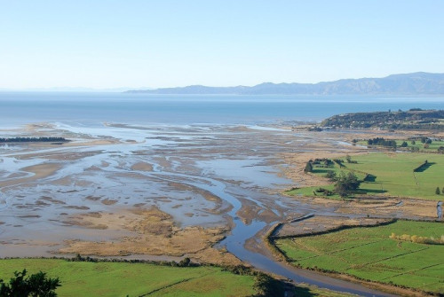
 Ruataniwha Inlet is a moderately large-sized (~850 ha), macrotidal (3.66 m spring tidal range), shallow (mean depth ~1-2 m at high water), well-flushed (<1 day residence time). It has a single wide tidal opening (1.6 km), one large basin, and several narrow upper estuary tidal arms (largely confined within river banks), several small causeways, and extensive areas of shoreline armouring.
The catchment (767 km2) is dominated by native forest and scrub (80%) and high producing pasture (10%), with much of the immediate estuary margin directly bordered by developed pasture /rural land, roads, causeways and seawalls.
More information and monitoring data is also available on the LAWA website.(external link)
The estuary contains a wide variety of intertidal habitats due, in part, to the strong influence of the Aorere River which enters the estuary in the south west and where extensive cobble, gravel, sand, and biogenic (cockle, mussel, tubeworm) habitats are located in the well flushed lower reaches of the estuary.
The estuary is dominated by intertidal sand and mudflats (firm mud sands (~200 ha), firm sands (~200 ha), soft muds (~90 ha)), as well as saltmarsh (~130 ha), seagrass (~12 ha), and cobble and gravel fields (~85 ha). Historical loss of high value saltmarsh habitat is likely to have been very high. Most saltmarsh modification is likely to have occurred prior to 1950. The loss of saltmarsh habitat will primarily have been due to reclamation and drainage around margin areas.
Shoreline modification (e.g. seawalls, bunds, roads) is expected to greatly limit natural saltmarsh expansion and restrict its capacity to migrate inland in response to predicted sea level rise. Thus under predicted scenarios of increasing sea level, saltmarsh is expected to become progressively displaced in the future.
The current major estuary stressors are considered to be: disease risk for contact recreation and shellfish gathering, habitat loss, increased muddiness, and changes in biota as a result of climate change.
Broad-scale mapping using the National Estuary Monitoring protocol was conducted in 2002 and 2015 and a fine-scale survey in 2002.
Last modified: