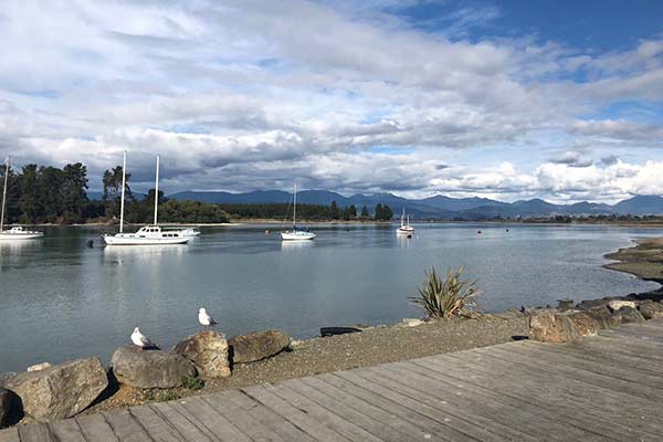
View near the Māpua Wharf
Popular with recreational boaties, it is close enough for an easy day trip from Nelson or Motueka in small vessels.
Māpua Wharf is owned by Tasman District Council.
It is recommended that transit through the channel be between the floats and ideally approximately 2 hours either side of high tide depending on vessel draft.
Tim Robinson (Wharf Custodian) 027 485 1283.
The approach to Port Māpua involves a sandbar that is subject to frequent change. It is recommended that recent local knowledge be sought before crossing the bar. Use a depth sounder in this area and travel at a safe speed at all times.
The least depth in the approaches is often about or shallower than chart datum.
An access lane for vessels transiting between Grossis Point and the sea is established under the Council's Navigation Safety Bylaw - see below. Vessels using the lane (on the Rabbit Island side of the channel) may travel at up to 15 knots.
Please take care to trim for minimal wake, and remember to keep right (to starboard) when passing other vessels. The access lane finishes at the port lateral mark pile.
The current over the bar and in the Māpua Channel can be very swift. During ebb tides, strong tidal overalls occur near the Leisure Park (as shown on Chart NZ614).
Be aware that a number of moorings lie in the Māpua Channel and near Grossi Point. The moorings are privately owned. Moored vessels generally do not show a light, and the buoys can sometimes sink in the strong currents.
There is poor anchor holding in the Māpua channel area. Anchoring is not recommended. Do not tie to a mooring without the owner’s permission.
The leading light beacons (NZ Light List 4220, 4220.1, 4220.2 and 4220.21) were decommissioned and removed in May 2012.
Lateral marks have been installed as follows:
| Type | Light | Latitude (WGS84) | Longitude (WGS84) | Council Structure ID |
|---|---|---|---|---|
|
Starboard lateral buoy (Fairway) |
Fl G 1m 3NM |
41°14.390'S |
173°07.470'E |
CST-1308 |
|
Port lateral buoy |
none |
41°14.764'S |
173°07.033'E |
CST-1312 |
|
Starboard outer lateral pile |
Fl (2) G 6s 3m 2NM |
41°14.844'S |
173°06.825'E |
CST-1309 |
|
Port lateral pile |
Fl R 3m 2NM |
41°15.001'S |
173°06.735'E |
CST-1311 |
The fairway buoy is at a depth of approximately 2m at chart datum and serves as a safe water mark for small vessels travelling in the conventional direction of buoyage (i.e clockwise around the South Island).
The unlit port lateral buoy marks an area of shoaling, and should not be used as the ‘outer mark’. The fairway buoy is more appropriate for this.
In general the best route into Māpua will be found by holding a line towards the lit starboard lateral pile from the lit starboard outer lateral Fairway buoy until about midway between the unlit port lateral buoy and that pile, then tending towards the lit port lateral pile. In daylight, steer down the access lane (more or less the port or eastern half of the channel proper) until opposite the outermost moorings. At night, from the lit port lateral pile steer towards the white floodlight on the seaward corner of the wharf buildings to approach the floating jetty. Use a spotlight to determine positions of moorings and moored vessels.
At August 2013, the least depth on the best approach is an area of cobble shoaling, angling roughly between the starboard pile and the unlit port lateral buoy.
Note that strong tidal overfalls and eddies can be experienced near the rock wall at the Māpua Leisure park on the western side of the channel. Vessels should tend toward the Rabbit Island or Eastern side of the channel when inshore of the port lateral pile.
The outer buoy positions may change from time to time in response to changes in the sandbar, or as a result of displacement in heavy weather. The channel is however generally stable inshore of the starboard lateral pile.
You must report any unintentional grounding or other mishap as soon as practicable to;
Maritime New Zealand
Phone 0508 225522
and
Tasman District Council
Harbourmaster
Phone 03 543 8400
VHF Channel 16
There is an inspection grid on the inshore side of the main wharf. Except in emergencies, use of the grid must be arranged in advance with the wharf custodian. Any biofouling or other contaminants (e.g paint residues) must be collected and properly disposed of ashore.
There is an attached floating pontoon jetty. Maximum vessel length is 10m at this jetty, no overnight berthing alongside permitted.
Unless authorisation is obtained in advance from the Harbourmaster, vessels alongside the jetty, wharf or inspection grid, or on a mooring, must remain in a seaworthy state at all times.
The Māpua Wharf precinct has a free internet connection available.
We’ve got together with IKS Internet Services and the Māpua Leisure Park to supply free Wi-Fi to the area.
The Leisure Park needed a new wireless connection and IKS needed somewhere to install its gear, so we reached an agreement for them to use space in one of our buildings at the wharf, in return for supplying free Wi-Fi to the area.
All you have to do is connect to “Tasman Free Wi-Fi" to get on line.
There’s a two-hour time limit, but that should be more than enough to keep your social media up to date with all those fabulous pictures of you enjoying all the great things Māpua has to offer.