Road safety is a shared responsibility between the council and the general public. Please help us keep our local roads safe.
In 2022 the Speed Limits bylaw was replaced by the National Speed Limit Register as the legal tool for setting speed limits.
If you have any questions, or would like any further information, please use this form to contact us
The objective of this Bylaw is to facilitate traffic management and parking control measures with respect to roads, public places and parking areas under the control of Tasman District Council.
The Bylaw came into effect on 1 November 2016.
The Traffic Control Bylaw 2016 is accompanied by the Traffic Control Devices Register and map display. The register is the mechanism for the Council to record all authorised existing traffic control devices under the Consolidated Bylaw – Chapter 7 – Traffic Control Bylaw.
By approving all existing traffic control devices in the register the Council ensures they can be enforced in the future.
During winter it’s important we are all extra cautious on the roads. Whether you’re driving, cycling, riding a motorcycle, or walking, safety is key. Here are a few things to consider to stay safe:
See and be seen
Slow down
The safest way to get where you need to go this winter is to slow down and drive to the conditions.
Winter sun can be dangerous, especially for drivers at certain times of the day. Sunstrike is a common cause of winter crashes.
Sunstrike can occur at any time during the day, but is most likely during sunrise or sunset when the sun’s rays hit your windscreen at a low angle. This can make it difficult, or even impossible, to see.
Over recent years, there have been several crashes on the switchbacks on Paton Road and Hill Street in Richmond, one involving significant injury, after drivers were blinded by the sun.
Here are a few tips to help you stay safe when the sun is at a low angle.
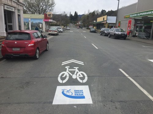
 Have you seen those markings painted on the road that have a double arrowhead combined with the outline of a bike and wondered what they actually mean?
They are sharrow markings. They’re a safety measure and are becoming more common around the District.
The word comes from a combination of share and arrow. A sharrow is a marking that shows a cyclist can share and position themselves within a traffic lane with other vehicles.
Sharrow markings are designed to alert all road users to sections of road where it is safest for cyclists to ‘take the lane’, for example in busy town centre areas where on-street parking creates hazards from car doors being opened.
Sharrows have been used internationally since the early 1990s and we’ve been using these markings on Tasman roads for the past few years.
So look out for sharrow markings on the road and be aware that vehicles and cyclists are sharing the same space.
There are areas identified as "shared zones" around our region. One notable example is the Māpua Wharf precinct at the end of Aranui Road.
In shared zones, there are no formal footpaths. The concept relies on the removal of typical street elements including line-markings, signage and kerbs, with the addition of extra street furniture such as seats, cycle parking and landscaping. This is designed to slow vehicle speeds and make it easier for everyone to interact safely.
In a shared zone, the needs and comfort of people on foot are paramount. Cyclists and drivers in these areas are expected to travel at walking pace and are legally required to give way to pedestrians.
However, pedestrians must not impede traffic either – it’s a case of sharing with care.
Look out for the signage that indicates when you are entering a shared zone.