The Materials Recovery Facility (MRF) at 14 Fittal St, Richmond, is being upgraded to improve recyclables sorting and baling. The project also includes expanding the MRF building to support more efficient operations.
|
Current status |
Planning |
|
Start Date |
Construction Start TBC |
|
End date |
TBC |
|
Access |
TBC |
|
Contractors |
TBC |
|
Cost |
TBC |
Contact: Email [email protected] for more information, reference 1505.
A new water pumping station will be constructed at the Selbourne Ave/Cropp Place reserve. The project includes upgraded mains and SCADA integration to improve system reliability and monitoring. These upgrades will help improve the stability and efficiency of the water supply for the area.
|
Current status |
Planning/ Design |
|
Start Date |
TBC |
|
End date |
March 2026 |
|
Access |
TBC |
|
Contractors |
TBC |
|
Cost |
TBC |
Contact: Email [email protected] for further information, reference 1513.
We are building a combined new right of way for residents and an infrastructure maintenance road. This project is part of enabling the wider stormwater improvement work for Richmond South.
|
Current status |
Construction |
|
Start Date |
Mid Feb 2025 |
|
End date |
May 2025 |
|
Access |
Shoulder will be closed through March and April, which means traffic will still be able to go through most of the time, with a day or two having stop/go for trenching across the road. |
|
Contractors |
Mike Edridge Contracting |
|
Cost |
$500,000 |
Contact: Email [email protected] for further information, reference 1570.
This project is to reduce the effects of overland flow path that runs through Easby Park and onto Selbourne Ave. This will in tale some stormwater structures being installed in Easby Park.
|
Current status |
Planning |
|
Start Date |
Construction Start: September 2025 |
|
End date |
Construction End: November 2025 |
|
Access |
TBC |
|
Contractors |
TBC |
|
Cost |
TBC |
Contact: Email [email protected] for more information, reference 1578.
Update March 2025
Upper Queen/Hill Street UNDERWAY
The water main on Queen Street between Hill St and #85 needs to be replaced due to its and age and condition. This also involves a pipe under the road and will close the Upper Queen Street section of road during works period. Works dates: 24th February 2025 – 4th April 2025. Once a separate project on Wensley Road works are complete (looking to be in April) we will then move on to Hill Street and have one way/stop go traffic management in place.
Update Jan 2025
Cautley Street - COMPLETE
The water main on Cautley Street between King Street and Giblin Street needs to be replaced due to its age and condition. Works have started and are expected for completion on 21st February 2025. From 4th February to 21st February, road access will be reinstated, with only a shoulder and footpath closed.
About the Project
This project is for a three year programme of reticulation renewals in the Tasman region. These renewals are an ongoing series of works across Tasman designed to renew failing water infrastructure.
First areas of work starting in Māpua and Richmond.
|
Current status |
Delivery |
|
Start Date |
Construction starting end of November as a rolling programme until mid 2027. |
|
End date |
June 2027 |
|
Access |
To be advised in each section. |
|
Contractors |
Ching Contracting |
|
Cost |
$1M |
Contact Us: Email [email protected] for further information reference 1534 Urban Water Reticulation Renewals
This project is to build a crossing (bridge) to State Highway 6 to allow connection of stormwater channel to Borck creek. The project will be starting with enabling works to relocate services out of the way and work plans for contaminated land remediation.
|
Current status |
Planning |
|
Start Date |
Construction start: 2029 |
|
End date |
Construction End: 2031 |
|
Access |
TBC |
|
Contractors |
TBC |
|
Cost |
TBC |
Contact: Email [email protected] for further information, reference 1273.
The Richmond South Stormwater Programme will support growth in Richmond South, south of Bateup Road.
This area currently floods during heavy rainfall, and the channel network being constructed will collect and convey water through Borck Creek. The channels are designed to handle a 1-in-100-year flood event, with an additional freeboard allowance to manage river turbulence during floods.
The network follows environmental principles aligned with cultural values under Te Mana o te Wai, incorporating native plantings, grassed areas, and paths for walking and cycling, similar to Richmond West.
The works, delivered through a series of projects, will coordinate with development activities and land purchases. It includes bridge construction and represents a significant investment in Richmond’s growth.
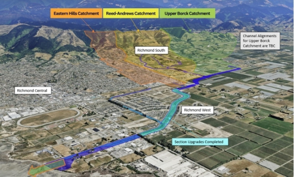
Diagram of Richmond South Stormwater Programme
Projects include:
| Project | Status |
| 1269 - Borck Creek Estuary to Lower Queen St environmental rejuvenation and capacity increase | Design underway, construction due to start 2026 |
| 1268 - Lower Queen St bridge capacity upgrade over Borck Creek | Design underway, construction due to start 2025. |
| 1251 - Borck Creek SH60 bridge Capacity Upgrade | Design complete, construction due to start mid 2026 |
| 1252 - Channel upgrade between SH60 and SH6 | Design underway, construction due to start 2029 |
| 1273 - SH6 Bridge capacity upgrade adjacent to Network Tasman | Design underway, construction due to start 2029 |
| 1404 - Channel and bridge construction through Pukerua Subdivision | Design complete, construction underway |
| 1317 - Channel construction between Cupola Crescent and Hill St South | Design underway, construction due to start 2026 |
| 1168 - Richmond Stormwater Land Purchase Programme | Purchase of additional land - ongoing |
The project involves the upgrade of Section H of the Richmond South Stormwater Upgrade Programme. This includes the installation of a section of watermain and wastewater main between Hill Street South and Cupola Crescent. It also includes the installation of a walkway between Cupola Crescent and Hill Street South. All of this is aimed to support growth in Richmond South.
|
Current status |
Design Phase |
|
Start Date |
Construction 2025 |
|
End date |
June 2026 |
|
Access |
To be advised |
|
Contractors |
Not yet appointed |
|
Cost |
$TBC |
Contact: [email protected] for further information, reference 1317.
This project is the replacement and upsizing of water mains pipe from 3 Brothers Corner to the intersection between Gladstone Road and Oxford Street. This pipe replacement will enable increased demands for water services and support growth in Richmond.
| Current status | Planning |
| Start Date | TBC |
| End date | 2026 |
| Access | To be advised |
| Contractors | Not yet appointed |
| Cost | $TBC |
Contact: [email protected] for further information, reference 1490.
Earthquake strengthening and repairs to the Richmond Library.
|
Current status |
Planning/Design |
|
Start Date |
April 2025 |
|
End date |
December 2025 |
|
Access |
TBC |
|
Contractors |
TBC |
|
Cost |
TBC |
Contact: Email [email protected] for further information, reference 1593
Update Jan 2025
Works are beginning at the Main Road Hope/Ranzau Road intersection towards the end of January and finish at Three Brothers Corner. Traffic and pedestrian management will be used for the duration of these works. Two lanes of traffic along Main Rd Hope will be maintained for all the works with restrictions on turning right out of businesses. Work hours will be weekdays and occasional Saturdays between 7:30am and 6:00pm, however, the traffic management will remain installed overnight and at weekends.
About the Project
This project is the renewal of water mains pipe Ranzau Road to Three Brothers Corner. This pipe replacement will enable increased demands for water services and support growth in Richmond.
| Current status | Delivery |
| Start Date | End of Jan 2025 |
| End date | 30 June 2025 |
| Access | Works alongside the State Highway will have traffic Management. Movement through the worksite will be retained at all times and access to private properties will also be mostly unaffected. |
| Contractors | Donaldson Civil |
| Cost | $2.2M |
Contact: Email [email protected] for further information, reference 1272.
This project is the widening of Borck Creek from SH60 to Reed Andrews Drain (Section C) to cater for growth in Richmond South.
First areas of work starting in Māpua and Richmond.
|
Current status |
Planning |
|
Start Date |
Construction to start 2031 |
|
End date |
Construction to end 2032 |
|
Access |
To be advised |
|
Contractors |
Not yet appointed |
|
Cost |
$TBC |
Contact: Email [email protected] for further information, reference 1252.
This project is the upgrade existing culvert to enable Borck Creek to be widened to cater for growth in Richmond South and reduce stormwater flooding.
| Current status | Design Phase - ON HOLD |
| Start Date | Construction TBC |
| End date | June 2029 |
| Access | To be advised |
| Contractors | Not yet appointed |
| Cost | TBC |
Email [email protected] for further information, reference project P1251.
This project is the rework of an existing cycle trail bridge to allow for a widened Borck Creek.
Essentially Borck Creek is being widened and Tasman’s Great Taste Trail utilises the vehicle access bridge to #81 Headingly Lane. When Borck creek is widened, the vehicle access will no longer be required, and a longer bridge will be required for cycle access.
It will be built to coincide with the Borck Creek Widening project.
| Current Status | Planning |
| Start date | Construction start date TBC |
| End Date | 2028 - Project timing needs to align with the widening of Borck Creek section A (Headingly Lane to Estuary), |
| Access | To be advised |
| Contractors | Not appointed yet |
| Cost | $TBC |
Contact: Email [email protected] for more information, reference 1556.
This project is to widen and deepen Channel A of Borck Creek to increase hydraulic capacity through these sections, and consequently to improve the level of service of the network through Richmond West, while addressing the aspirations of the Council’s Urban Stormwater Strategy and the Richmond Catchment Management Plan.
| Current status | Design Phase |
| Start Date | Construction July 2026 |
| End date | June 2027 |
| Access | To be advised |
| Contractors | Not yet appointed |
| Cost | $TBC |
Email [email protected] for further information.
Richmond Reticulation Lower Queen Street Trunkmain Upgrade
Lower Queen Street’s trunk main from the intersection with SH6 (Gladstone Road/ Lower Queen St) to just after the intersection with Headingly Lane is a 1960's asbestos pipeline and is nearing the end of its operational life. This project is to upgrade this to modern pipe material and provide more movement and resilience in the ground, all part of moving water where it needs to go in our region.
| Current status |
In design |
| Start Date |
On hold until 2031 |
| End date |
On hold until 2031 |
| Access |
To be advised |
| Contractors |
Not yet appointed |
| Cost |
$TBC |
Contact: Email [email protected] for further information, reference 1449.
As Richmond South and West grow, we’re upgrading the stormwater network to manage increased runoff, reduce flood risks, and prepare for future climate change impacts. The project focuses on Sections A and B1, which are key channels near Lower Queen Street. These sections, along with the existing road crossing, need upgrades to ensure the whole system works effectively.
The improvements include widening and deepening stormwater channels, upgrading the Lower Queen Street crossing, and ensuring the system meets future climate needs. This work supports the Council’s Urban Stormwater Strategy and will create a more resilient network for Richmond West. Design work began in 2023, and we’ll keep the community updated as the project progresses.
For most recent updates on this project, you can visit Lower Queen Street bridge upgrade | Shape Tasman
| Current status | Construction phase |
| Start Date | May 2025 |
| End date | June 2026 |
| Access | To be advised closer to the time of construction |
| Contractors | Fulton Hogan |
| Cost | $10.09m |
For more information, contact [email protected], reference 1268.
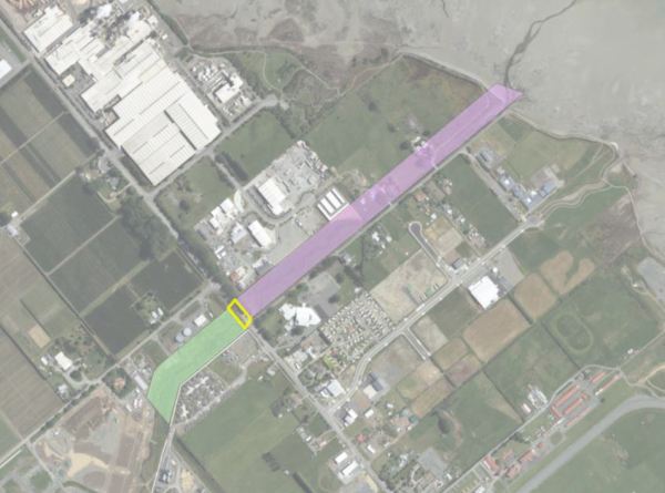
Update September 2024
All work is now complete except Section H - See Project Richmond South Section H on this projects page for latest information.
We are installing a new water main from the Richmond water treatment plant to a new reservoir planned for Richmond south. The work is being undertaken in stages in co-operation with private land developers.
This work will improve the resilience of Richmond's water supply and is required to service growth. There are extensive plans for new subdivisions in Richmond west and south in the coming years. This upgrade will ensure we can deliver consistent water supply to all existing and new customers.
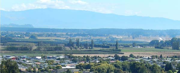
There will be major growth in the Richmond South-West area in the next five years.
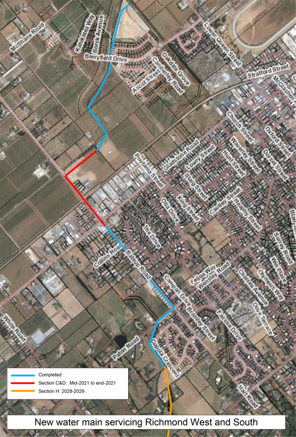
Click to view a larger version in a new window.
Update January 2025
We have the contractors on board (Fulton Hogan) and their work is set to start February 2025 with an aim to be completed at early 2026. There will be a small increase in the number of vehicles in the area, including heavy trucks and construction vehicles travelling along Hill Street South during construction hours 7am to 6pm. Please remember to take note of all the safety signage and take extra care while using the Hills Street South Road, White Road.
|
Current status |
Construction Phase |
|
Start date |
Construction Feb 2025 |
|
End date |
December 2026 |
|
Access |
There will be a small increase in the number of vehicles in the area, including heavy trucks and construction vehicles travelling along Hill Street South during construction hours. Please remember to take note of all the safety signage and take extra care while using roads in the area. |
|
Contractors |
Fulton Hogan |
|
Cost |
$4.97m |
Richmond is growing a lot faster than previously anticipated. The growth has seen a number of new subdivisions already constructed, and more staged development planned for the Richmond South area, such as Hart Rise and Paton Rise.
More households mean an increased demand for water supply, so we’re planning to build a new concrete water reservoirs (tank) to meet that need.

Artist's impression of new tanks from Hill St South (after approx. ten years planting growth)
The proposed location for the new reservoirs is on a Council owned property at 520 Hill Street South, west of Richmond’s Central Business District (refer map below).
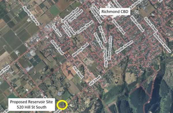
Location of new reservoirs
We looked at a number of possible locations for the reservoir, before choosing this site. As well as having easy access to build and maintain the tanks, an important factor was the ground height, which needed to be at 63m above sea level. That is so the top water level of the new reservoir will be the same level as the existing Richmond Queen Street reservoir, giving us the right conditions to connect the two water supply zones.
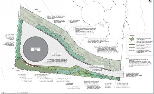
520 Hill Street South site location map
A new water main pipe, which is already partly built, will connect the Hill Street South reservoirs to the Richmond water treatment plant. The water main pipe runs along Borck Creek, adjacent the state highway, up Bateup Road Stream, and through the new developments at Hart Rise and Paton Rise.
Visit the project page to find out more about the new water main.
The reservoir could rise up to 9 metres in height from the base, but that will depend on how far we need to cut in to reach a suitable ground base to build on. Our preferred site option will require the least amount of earthworks to prepare the tank site. It also has the narrowest profile, the smallest silhouette and the smallest site footprint of the four options.
Contact Us: Email [email protected] for further information, reference 1141.
Update August 2024
Our Gladstone-Poutama stormwater connection project is progressing, with photos below showing installation of a ‘Cascade gross pollutant trap’ and ‘Jellyfish storm filter’ out-letting into Poutama Creek. The Cascade trap works to remove hydrocarbons, litter and debris from stormwater runoff while the Jellyfish uses special filtration cartridges to further remove pollutants from entering waterways. We decided to implement both of these new engineering technologies in this project in Richmond to keep our waterways as clean as possible while being easy to maintain.
A gravel path that will double as maintenance access is included in the work to better connect Eton Street to the Railway Reserve. Photo below shows works update in August:
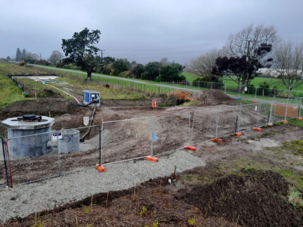
About the project
This project involves getting the pipe from Gladstone Road operational and improving the water quality of flows coming from the smaller stormwater pipe from the Poutama Street industrial area. The design seeks to minimise putting any assets into the outlet area as it is within the Hope Bypass Designation.
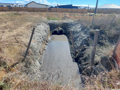
| Current status | In construction |
| Start Date | Underway |
| End date | Early October 2024 |
| Access | N/A |
| Contractors | Downer |
| Cost | $370K |
Contact
Project Manager: Giles Griffith
Email [email protected] for further information.
Complete March 2024
Earthworks to complete section B3 of the Borck Creek floodway north of Appleby Highway were completed ahead of programme this month.
We will be establishing vegetation over autumn/winter and installing a low flow bridge crossing to connect to paths on either side. Photos below show the recent completion.
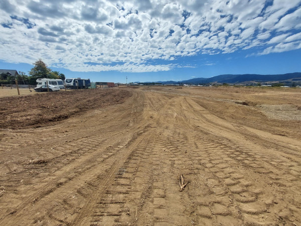
Borck Creek Floodway Feb 2024
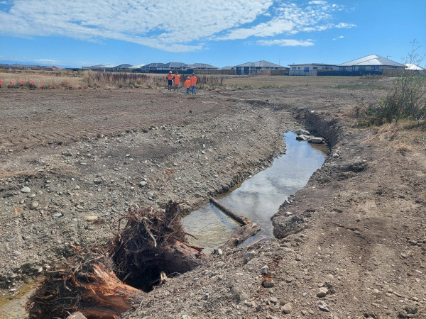
Low flow channel which has woody debris and steep sided pools excavated below the summer water table for fish refuge
December 2023 Update:
Construction of the upstream section of Borck creek will begin in January 2024.
This contract was awarded to Taylors Contracting.
The first stage of the work involves constructing a new private accessway as the creek excavation will remove an existing accessway. This will stop short of Appleby highway at the confluence with the new Eastern Hills Creek. Some gravel paths and a low flow bridge crossing the channel will also be constructed.
Winter planting will be undertaken following on from this work including downstream reaches of Borck Creek that require further planting
Borck Creek after the upgrade
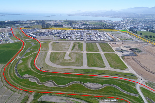
Overview of the site, Borck Creek shown in red and Poutama Stream shown in yellow.
Borck Creek and its tributaries, such as Poutama Stream, carry stormwater from the southern and western fringes of Richmond to the sea at Headingly Lane.
Development in both of these areas is putting greater demand on the channels and increasing the impact of flooding.
To minimise these effects, we’re upgrading both Borck Creek and Poutama Stream, by widening and deepening the channels. This will mean they can carry more water, which reduces the risk of flooding.
Construction and planting of the channels through the Richmond West development (Berryfields) is now complete.
Construction of the channel will progress upstream alongside development and the channel will be opened progressively as each stage of the new subdivisions are completed.
As part of the development of Borck Creek and Poutama Stream, we're building a new bridge to complete Berryfield Drive. The new bridge will connect The Meadows development on the McShane Road side of Borck Creek to The Fields/Applebyfields development, on the Richmond side.
This project is a long-term staged plan, which began in 2015.
During each stage of development, residents and people using the recreational areas next to the section being upgraded may experience some noise, dust, and vibration from the works.
|
Current status |
In construction. |
|
Start date |
2015 |
|
End date |
2027 |
|
Access |
Generally, access will be maintained, but areas under construction will be cordoned off. |
|
Contractors |
Various |
You can view images of how the completed project will look here (pdf, 3.7 MB).
The Landscape Plans are available in this memo (pdf, 4.2 MB).
The designs for the walkways currently under construction can be viewed and downloaded from the links below.
Contact us: [email protected]
Complete July 2024
Background to Residential Greenways Projects:
Residents around Crescent Street in Richmond came to the Council seeking support to create a Neighbourhood Greenway.
Neighbourhood Greenways are streets where vehicle numbers and speeds are reduced to create a safer, more pleasant environment for everyone. Streets that become Neighbourhood Greenways commonly incorporate physical changes to ensure low speed environments.
For example, a Neighbourhood Greenway might be a street that is one-way for cars but allows people to cycle in either direction. They may also involve street closures, speed humps or cushions, and reduced speed limits.
Amongst the solution that the respondents recommended were:
Using these links, you can read the full response to the questions we posed in the survey asking about current issues (pdf 78 KB) and future ideas (pdf 61 KB).
Project summary
Back in 2020, we launched a programme to find out what people thought about the streets they live in, and what improvements could be made to them.
The aim was to make these streets more liveable and safer for people, rather than just serving as transportation corridors.
We worked closely with residents, schools, kindys and other stakeholders to design solutions to improve neighbourhoods. We tried calming the traffic, bringing in more greenery, redesigning local parks, and creating more space for cycling and recreation.
As a result, and after a lot of community discussion and feedback, we proved what worked and what didn’t and now we have successfully completed several projects across Richmond.
We need to make the neighbourhood safer for all residents, especially children and people with limited mobility, remember speed determines whether a person will live or die in an accident.
Research suggests that the probability of a fatality is significantly reduced for a pedestrian or cyclist when a car’s speed is below 30km per hour, and this is the principal reason why we are introducing the intersection raised speed tables.
The tables have the dual benefit of reducing speeds where pedestrians cross and they also discourage drivers from using the neighbourhood as a shortcut.
Most Recent Upcoming Projects 2024/25
Detailed plans for each of the above are linked below.
Crescent Street Oxford Street (pdf 3.4 MB)
Olympus Way - Middlebank Drive (pdf 1.6 MB)
Recently completed projects Residential Greenways 2022/2023
Council awarded Contract 1265 Residential Greenways 2022/2023 to Asphalt and Construction Ltd on 13 April 2023.
Project completed July 2024
Richmond’s newest recreation area is open! Ascot Reserve is the first of four spaces that will be developed in the Berryfields area, the other three coming online over the next few years.
Each space will have its own colour scheme, tying in the vegetation with the play equipment and any structures. Ascot Reserve has a predominantly red colour scheme, reflected in the vegetation, including native Pohutukawa trees and fruit trees like feijoas and plums.
We collaborated with the community to understand their needs and believe we’ve successfully met their expectations. The play area is suitable for all age groups and is easily visible to parents sitting on the benches. There is also a concrete path for kids to ride their scooters on.
We’ve planted deciduous trees along the path that will provide shade and add beautiful colours in autumn, enhancing the view of the mountains in the background. The gardens add texture to the landscape with mounds of garden space that will fill in over time to create a cosy atmosphere.
This is a great new community asset, and we look forward to the next one.
Background
The development of Ascot Reserve, a 2770 square metre reserve located between Ascot and Bedfont Streets in the Berryfields subdivision, is set to begin shortly.
In January, we asked residents for feedback on what they would like to see in this new park space. Thanks to everyone who offered their suggestions. We have tried to accommodate your feedback as much as possible, within the available scope and budget.
We have now confirmed the final design and contractors will begin work in late April or early May 2024.
As well as constructing some play essentials like a swing, slide, rock scramble and bench seats for those who’d prefer to save some energy, we’ve also included a few other aspects to broaden the appeal.
Fruit and feature trees will provide plenty of shade across the park, as well as some beautiful greenery to enjoy within your neighbourhood.
We hope this new reserve will be enjoyed by residents and visitors to Richmond West, Berryfields, the Fields and the Meadows Community.
The Richmond Streets for People project received Government Funding of $2.4 million to shape the beginnings of a network of safe walking and cycling spaces in our streets.
Over the next two years, we will create and improve spaces for safer cycling on Salisbury Road, Wensley Road, Queen Street, Hill Street and Champion Road, linking places where people live with schools, commercial centres and the wider existing network of cycle trails.
For more information please visit: Streets for People | Shape Tasman
Update March 2024
With the completion of William Street package in Feb 2024, this project is now complete.
Building further from "Innovating Streets" and "Streets for People" projects , the council is particularly addressing the critical pedestrian and cycle safety needs at key intersections that currently don't have any seperation and present the most significant barriers to mode shift. Tasman District Council's walking and cycling strategy sets a target on increasing the proportion of trips to work and school within Richmond from 19% in 2018 to 40% by 2030.
Visit http://bit.ly/3yTL9hB to view the map and find more information.
Visit Transport Choices 2023 | Shape Tasman for more information.
Why is this Programme Important?
It’s important because transport makes up almost half of New Zealand’s carbon emissions, most of which comes from road transport.
Under the Government’s emissions reduction plan, a $350 million Transport Choices package was made available from the Climate Emergency Response Fund (CERF).
As part of this package, Waka Kotahi will be working with Tasman District Council to:
Currently a lot of infrastructure to support active transport modes is not safe enough for majority of people, and often disconnected. Having greater transport choices will ensure people can access all their needs, while creating safer and healthier environments for communities across Aotearoa, New Zealand.
Over the next 12 to 18 months, we are embarking on an extensive programme improving pedestrian crossings plus several intersection upgrades including new and redesigned roundabouts.
We're even building new covered cycle parks and improving bus stops to make way for the new extended public bus routes.
This is in addition to the government-funded Streets for People programme which is also currently happening in Richmond and Māpua.
The Streets for People programme aims to make it easier and faster to create more people-friendly streets with $2.4 million in government money being injected into Richmond to create a network of safe walking and cycling spaces in our streets.
The Transport Choices Fund is part of the Government’s Climate Emergency Response Fund, $350 million has been distributed to councils to take a broader approach to improve road safety and transport options.
Because there are so many individual projects within the Transport Choices programme, we’ve put together a special interactive online map that shows you what we are doing and where we are doing it. Just click on the icon and you’ll get an explanation about each piece of work.