Scroll down past the map for more details on the projects listed. You can also open the map in a new window(external link).
Update March 2025
Upper Queen/Hill Street UNDERWAY
The water main on Queen Street between Hill St and #85 needs to be replaced due to its and age and condition. This also involves a pipe under the road and will close the Upper Queen Street section of road during works period. Works dates: 24th February 2025 – 4th April 2025. Once a separate project on Wensley Road works are complete (looking to be in April) we will then move on to Hill Street and have one way/stop go traffic management in place.
Update Jan 2025
Cautley Street - COMPLETE
The water main on Cautley Street between King Street and Giblin Street needs to be replaced due to its age and condition. Works have started and are expected for completion on 21st February 2025. From 4th February to 21st February, road access will be reinstated, with only a shoulder and footpath closed.
About the Project
This project is for a three year programme of reticulation renewals in the Tasman region. These renewals are an ongoing series of works across Tasman designed to renew failing water infrastructure.
First areas of work starting in Māpua and Richmond.
|
Current status |
Delivery |
|
Start Date |
Construction starting end of November as a rolling programme until mid 2027. |
|
End date |
June 2027 |
|
Access |
To be advised in each section. |
|
Contractors |
Ching Contracting |
|
Cost |
$1M |
Contact Us: Email [email protected] for further information reference 1534 Urban Water Reticulation Renewals
A new water pumping station will be constructed at the Selbourne Ave/Cropp Place reserve. The project includes upgraded mains and SCADA integration to improve system reliability and monitoring. These upgrades will help improve the stability and efficiency of the water supply for the area.
|
Current status |
Planning/ Design |
|
Start Date |
TBC |
|
End date |
March 2026 |
|
Access |
TBC |
|
Contractors |
TBC |
|
Cost |
TBC |
Contact: Email [email protected] for further information, reference 1513.
The Materials Recovery Facility (MRF) at 14 Fittal St, Richmond, is being upgraded to improve recyclables sorting and baling. The project also includes expanding the MRF building to support more efficient operations.
|
Current status |
Planning |
|
Start Date |
Construction Start TBC |
|
End date |
TBC |
|
Access |
TBC |
|
Contractors |
TBC |
|
Cost |
TBC |
Contact: Email [email protected] for more information, reference 1505.
We are building a combined new right of way for residents and an infrastructure maintenance road. This project is part of enabling the wider stormwater improvement work for Richmond South.
|
Current status |
Construction |
|
Start Date |
Mid Feb 2025 |
|
End date |
May 2025 |
|
Access |
Shoulder will be closed through March and April, which means traffic will still be able to go through most of the time, with a day or two having stop/go for trenching across the road. |
|
Contractors |
Mike Edridge Contracting |
|
Cost |
$500,000 |
Contact: Email [email protected] for further information, reference 1570.
Earthquake strengthening and repairs to the Richmond Library.
|
Current status |
Planning/Design |
|
Start Date |
April 2025 |
|
End date |
December 2025 |
|
Access |
TBC |
|
Contractors |
TBC |
|
Cost |
TBC |
Contact: Email [email protected] for further information, reference 1593
This project is to reduce the effects of overland flow path that runs through Easby Park and onto Selbourne Ave. This will in tale some stormwater structures being installed in Easby Park.
|
Current status |
Planning |
|
Start Date |
Construction Start: September 2025 |
|
End date |
Construction End: November 2025 |
|
Access |
TBC |
|
Contractors |
TBC |
|
Cost |
TBC |
Contact: Email [email protected] for more information, reference 1578.
The project involves the upgrade of Section H of the Richmond South Stormwater Upgrade Programme. This includes the installation of a section of watermain and wastewater main between Hill Street South and Cupola Crescent. It also includes the installation of a walkway between Cupola Crescent and Hill Street South. All of this is aimed to support growth in Richmond South.
|
Current status |
Design Phase |
|
Start Date |
Construction 2025 |
|
End date |
June 2026 |
|
Access |
To be advised |
|
Contractors |
Not yet appointed |
|
Cost |
$TBC |
Contact: [email protected] for further information, reference 1317.
As Richmond South and West grow, we’re upgrading the stormwater network to manage increased runoff, reduce flood risks, and prepare for future climate change impacts. The project focuses on Sections A and B1, which are key channels near Lower Queen Street. These sections, along with the existing road crossing, need upgrades to ensure the whole system works effectively.
The improvements include widening and deepening stormwater channels, upgrading the Lower Queen Street crossing, and ensuring the system meets future climate needs. This work supports the Council’s Urban Stormwater Strategy and will create a more resilient network for Richmond West. Design work began in 2023, and we’ll keep the community updated as the project progresses.
For most recent updates on this project, you can visit Lower Queen Street bridge upgrade | Shape Tasman
| Current status | Construction phase |
| Start Date | May 2025 |
| End date | June 2026 |
| Access | To be advised closer to the time of construction |
| Contractors | Fulton Hogan |
| Cost | $10.09m |
For more information, contact [email protected], reference 1268.
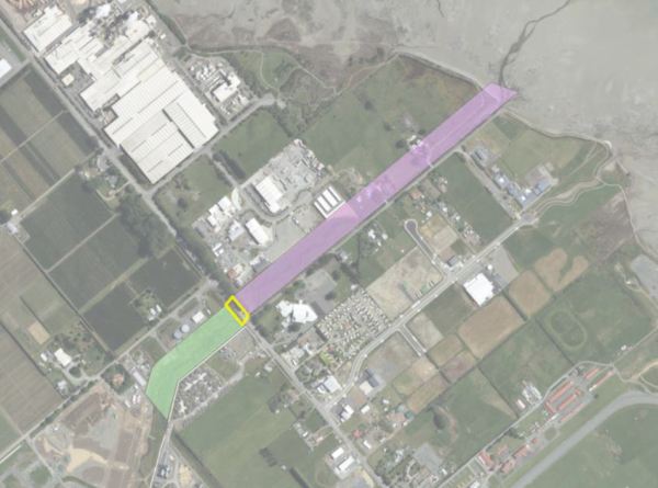
This project is to build a crossing (bridge) to State Highway 6 to allow connection of stormwater channel to Borck creek. The project will be starting with enabling works to relocate services out of the way and work plans for contaminated land remediation.
|
Current status |
Planning |
|
Start Date |
Construction start: 2029 |
|
End date |
Construction End: 2031 |
|
Access |
TBC |
|
Contractors |
TBC |
|
Cost |
TBC |
Contact: Email [email protected] for further information, reference 1273.
This project is the replacement and upsizing of water mains pipe from 3 Brothers Corner to the intersection between Gladstone Road and Oxford Street. This pipe replacement will enable increased demands for water services and support growth in Richmond.
| Current status | Planning |
| Start Date | TBC |
| End date | 2026 |
| Access | To be advised |
| Contractors | Not yet appointed |
| Cost | $TBC |
Contact: [email protected] for further information, reference 1490.
This project is the upgrade existing culvert to enable Borck Creek to be widened to cater for growth in Richmond South and reduce stormwater flooding.
| Current status | Design Phase - ON HOLD |
| Start Date | Construction TBC |
| End date | June 2029 |
| Access | To be advised |
| Contractors | Not yet appointed |
| Cost | TBC |
Email [email protected] for further information, reference project P1251.
This project is the widening of Borck Creek from SH60 to Reed Andrews Drain (Section C) to cater for growth in Richmond South.
First areas of work starting in Māpua and Richmond.
|
Current status |
Planning |
|
Start Date |
Construction to start 2031 |
|
End date |
Construction to end 2032 |
|
Access |
To be advised |
|
Contractors |
Not yet appointed |
|
Cost |
$TBC |
Contact: Email [email protected] for further information, reference 1252.
This project is the rework of an existing cycle trail bridge to allow for a widened Borck Creek.
Essentially Borck Creek is being widened and Tasman’s Great Taste Trail utilises the vehicle access bridge to #81 Headingly Lane. When Borck creek is widened, the vehicle access will no longer be required, and a longer bridge will be required for cycle access.
It will be built to coincide with the Borck Creek Widening project.
| Current Status | Planning |
| Start date | Construction start date TBC |
| End Date | 2028 - Project timing needs to align with the widening of Borck Creek section A (Headingly Lane to Estuary), |
| Access | To be advised |
| Contractors | Not appointed yet |
| Cost | $TBC |
Contact: Email [email protected] for more information, reference 1556.
Richmond Reticulation Lower Queen Street Trunkmain Upgrade
Lower Queen Street’s trunk main from the intersection with SH6 (Gladstone Road/ Lower Queen St) to just after the intersection with Headingly Lane is a 1960's asbestos pipeline and is nearing the end of its operational life. This project is to upgrade this to modern pipe material and provide more movement and resilience in the ground, all part of moving water where it needs to go in our region.
| Current status |
In design |
| Start Date |
On hold until 2031 |
| End date |
On hold until 2031 |
| Access |
To be advised |
| Contractors |
Not yet appointed |
| Cost |
$TBC |
Contact: Email [email protected] for further information, reference 1449.
Update Jan 2025
Works are beginning at the Main Road Hope/Ranzau Road intersection towards the end of January and finish at Three Brothers Corner. Traffic and pedestrian management will be used for the duration of these works. Two lanes of traffic along Main Rd Hope will be maintained for all the works with restrictions on turning right out of businesses. Work hours will be weekdays and occasional Saturdays between 7:30am and 6:00pm, however, the traffic management will remain installed overnight and at weekends.
About the Project
This project is the renewal of water mains pipe Ranzau Road to Three Brothers Corner. This pipe replacement will enable increased demands for water services and support growth in Richmond.
| Current status | Delivery |
| Start Date | End of Jan 2025 |
| End date | 30 June 2025 |
| Access | Works alongside the State Highway will have traffic Management. Movement through the worksite will be retained at all times and access to private properties will also be mostly unaffected. |
| Contractors | Donaldson Civil |
| Cost | $2.2M |
Contact: Email [email protected] for further information, reference 1272.
Update September 2024
All work is now complete except Section H - See Project Richmond South Section H on this projects page for latest information.
We are installing a new water main from the Richmond water treatment plant to a new reservoir planned for Richmond south. The work is being undertaken in stages in co-operation with private land developers.
This work will improve the resilience of Richmond's water supply and is required to service growth. There are extensive plans for new subdivisions in Richmond west and south in the coming years. This upgrade will ensure we can deliver consistent water supply to all existing and new customers.
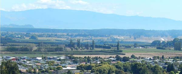
There will be major growth in the Richmond South-West area in the next five years.
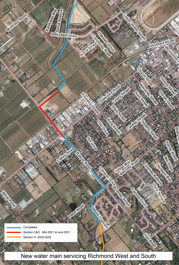
Click to view a larger version in a new window.
Update January 2025
We have the contractors on board (Fulton Hogan) and their work is set to start February 2025 with an aim to be completed at early 2026. There will be a small increase in the number of vehicles in the area, including heavy trucks and construction vehicles travelling along Hill Street South during construction hours 7am to 6pm. Please remember to take note of all the safety signage and take extra care while using the Hills Street South Road, White Road.
|
Current status |
Construction Phase |
|
Start date |
Construction Feb 2025 |
|
End date |
December 2026 |
|
Access |
There will be a small increase in the number of vehicles in the area, including heavy trucks and construction vehicles travelling along Hill Street South during construction hours. Please remember to take note of all the safety signage and take extra care while using roads in the area. |
|
Contractors |
Fulton Hogan |
|
Cost |
$4.97m |
Richmond is growing a lot faster than previously anticipated. The growth has seen a number of new subdivisions already constructed, and more staged development planned for the Richmond South area, such as Hart Rise and Paton Rise.
More households mean an increased demand for water supply, so we’re planning to build a new concrete water reservoirs (tank) to meet that need.

Artist's impression of new tanks from Hill St South (after approx. ten years planting growth)
The proposed location for the new reservoirs is on a Council owned property at 520 Hill Street South, west of Richmond’s Central Business District (refer map below).
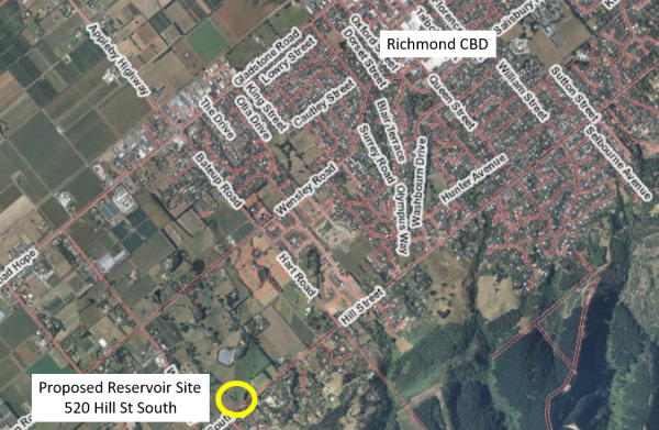
Location of new reservoirs
We looked at a number of possible locations for the reservoir, before choosing this site. As well as having easy access to build and maintain the tanks, an important factor was the ground height, which needed to be at 63m above sea level. That is so the top water level of the new reservoir will be the same level as the existing Richmond Queen Street reservoir, giving us the right conditions to connect the two water supply zones.
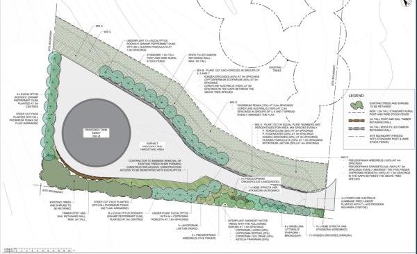
520 Hill Street South site location map
A new water main pipe, which is already partly built, will connect the Hill Street South reservoirs to the Richmond water treatment plant. The water main pipe runs along Borck Creek, adjacent the state highway, up Bateup Road Stream, and through the new developments at Hart Rise and Paton Rise.
Visit the project page to find out more about the new water main.
The reservoir could rise up to 9 metres in height from the base, but that will depend on how far we need to cut in to reach a suitable ground base to build on. Our preferred site option will require the least amount of earthworks to prepare the tank site. It also has the narrowest profile, the smallest silhouette and the smallest site footprint of the four options.
Contact Us: Email [email protected] for further information, reference 1141.
This project is to widen and deepen Channel A of Borck Creek to increase hydraulic capacity through these sections, and consequently to improve the level of service of the network through Richmond West, while addressing the aspirations of the Council’s Urban Stormwater Strategy and the Richmond Catchment Management Plan.
| Current status | Design Phase |
| Start Date | Construction July 2026 |
| End date | June 2027 |
| Access | To be advised |
| Contractors | Not yet appointed |
| Cost | $TBC |
Email [email protected] for further information.
Upgrade reticulation within Wakefield and 88 Valley to allow the majority of the 88 Valley area to be supplied from the Wakefield network via a new line from Gossey Drive North to Totara View Reservoirs. This is all part of improving water supplies to this area. This project is being done in stages.
Stage 1: Construction of pump station in Gossey Drive North and connection of pipeline in Edward St to the new pump station.
| Current status | Delivery |
| Start Date | Jan 2025 |
| End date | End of March 2025 |
| Access | We have traffic management in place in Edward St and Gossey Drive North |
| Contractors | Downer and Process Flow |
| Cost | $1.5m |
Stage 2: Connection of the pump station with the tanks at Totara View
| Current status | Design |
| Start Date | 2026 |
| End date | 2026 |
| Access | TBC |
| Contractors | TBC |
| Cost | $TBC |
Contact: Email [email protected] reference project 1256.
February Update
Works are in full swing for the next phase of the Motueka River Stopbank Refurbishment project, aimed at strengthening flood resilience in the community.
Current progress:
Traffic & Safety:
Access & Next Steps:
What are we doing?
We’re about to get started on our next phase of work on the Lower Motueka River stopbank network, to build resilience and reduce the community’s risk of flooding from the river.
Following the successful completion of Stage One earlier this year, funding for the Motueka Stopbanks Refurbishment Project Stage Two was approved by Kānoa Regional Economic Development & Investment Unit, as part of the Government’s Resilient Infrastructure Fund.
We received a grant of $7.5 million from Kānoa, of which $6.6 million will go towards work on the Lower Motueka River stopbank refurbishment, and $900,000 going towards stopbank repairs at Peach Island. We are providing another $5 million in co-funding for a total project budget of $12.5 million.
The Lower Motueka River and Brooklyn Stream stopbanks are to have a 6.7km upgrade, building on the 4.8km initial stage of work. The stopbank refurbishment on the Lower Motueka River would protect approximately 1,500 hectares of fertile and productive land, along with portions of the town itself.
So far, we have carried out some initial sonic borehole drilling to recover soil core samples, which helps us better understand the ground conditions for the work ahead. We are now planning to begin construction on the first work package in January 2025.
Where we are working:
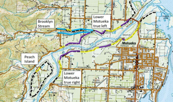
Purple lines are new works planned, Yellow was completed in phase 1, blue lines are Brooklyn Stream stopbank works.
How will it affect me?
The river itself won’t be affected, but if you use the riverbanks for recreation, you may find access to sections of the stopbank temporarily restricted or closed off, so check before you make any plans.
|
Current status |
Delivery |
|
Start Date |
Construction start: Jan 2025 for year one works. |
|
End date |
Total works will be May 2028 |
|
Access |
TBC |
|
Contractor (Main) |
Taylors Contracting Ltd |
|
Cost |
$1.3m for Stage 1 works |
Contact: Email [email protected] for further information, reference project 1572.
We’re sourcing material (soil) from Tasman View Road for the next phase of the Motueka River Stopbank Refurbishment project. At the same time, we’ll be upgrading a section of the road to improve it for future use.
How will it affect me?
Between Wednesday 29 January and Thursday 15 May 2025, Tasman View Road between Harley and Flaxmore Road will be closed to the public while a section of the road is upgraded. Beyond the signposted closure points, the rest of Tasman View Road will remain open.
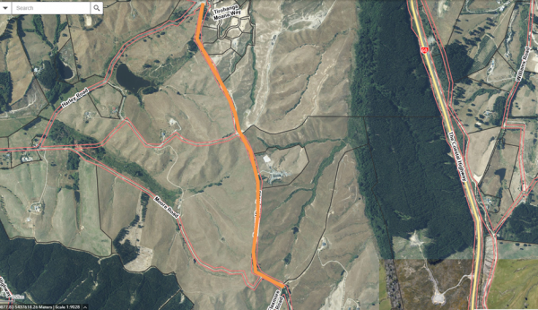
Tasman View Road - Orange area where works will be
We appreciate that this closure will affect recreational users of Tasman View Road, especially for those looking to link with the Great Taste Trail cycleway during the works period.
For your own safety, please follow all signage and instructions from the project team situated at each end of the road.
We will continue to update everyone on progress in the coming weeks through our various channels, including the Council’s Antenno app.
Contact info: Email [email protected] or see Motueka Stopbanks Phase Two (1572) for further information on the project.
We have projects set up to look and improve these existing treatment plants to reduce impact on the environment and meet modern standards.
We are starting with Collingwood, Tākaka and Motueka and improving their Secondary Treatment Systems by investigating the work required and engaging special expertise.
We are looking at nutrient loading, decreasing solids and stormwater flows in all three plants, as well as reducing nitrogen and ammonia that is produced.
|
Current status |
In design |
| Start Date | TBC |
| End date | TBC |
| Access | N/A |
| Contractors |
Not yet appointed |
| Cost | $TBC |
Contact: Email [email protected] for further information, reference P1450/1587.
This project is to design and build a community pool for Motueka.
You can find more information on this project here: Motueka Pool | Shape Tasman.
| Current status | Planning |
| Start Date | TBC |
| End date | TBC |
| Access | To be advised |
| Contractors | TBC |
| Cost | TBC |
Contact: Email [email protected], reference project 1530.
September 2024 Update:
Stage 2 is 100% complete and the pump station is currently on hold until further developments.
November 2023 Update:
Stage Two: New Wastewater rising main from Pah Street - Motueka Bridge
Stage 2 is over 50% complete. The priority was to complete the construction on State highway 60 before the holiday season.
The team are now working along Parker Street heading towards Atkins Street. 1700m of pipe has been laid out of the proposed 3000m and on track to the programme.
October 2023:
This stage of the project is for the installation of a new polyethylene (PE) wastewater rising main approximately 3 kilometres long. The pipeline alignment will follow Pah Street, Atkins Street, Parker Street, High Street and Lyndhurst Avenue (SH60). All sections can be installed via open trenching methods, with the exception of a short section beneath the Motueka River stopbank which will require use of a trenchless installation technology.
The pipeline will serve the growing communities in Motueka West, conveying wastewater from development there to the wastewater treatment plant.
The pipeline alignment will start at Lyndhurst Avenue SH60 at the Motueka River Bridge and continue along High Street, Parker Street, Atkins Street and Pah Street. All sections of the pipeline will be installed via open trenching.
There are eight phases for this portion of the works. Phase one – between Lyndhurst Ave SH60 to Parker Street turn-off – has now finished.
Beginning in October 2023, work will move along Parker St to the intersection at Te Maatu Drive through to Wilkie Street. From Monday 9 October, the intersection at Te Maatu Drive will be closed so access from High Street into Parker St will only be available for residents in this first section. We expect this stage to take approximately three weeks.

The overall Rising Main project is planned to be completed by May 2024.
We are mindful of the impact that wait times can have on people’s day, and we are aiming to keep these to a minimum.
We thank you in advance for your patience and cooperation during this work.

Stage One: COMPLETE
What are we doing?
To enable growth in this less flood prone and sea level rise affected area, a new pump station and rising main must be installed to deliver wastewater to the wastewater treatment plant (WWTP), pumping via a shared main starting at the Motueka River Bridge.

Why are we doing it?
This project is necessary to serve and enhance any Motueka West developments and incudes the installation of wastewater rider mains along Grey Street from the Green Lane intersection North to Pah Street. The water main will follow the same alignment with an additional branch east along Whakarewa street past Motueka High School.
How will it affect me?
Start Date: 22 August 2022
End Date: January 2023
Contractor: CJ Industries Ltd
Site Contact: Morgan Corrie-Johnston - 021 307 145
Contact: Email [email protected] reference project 1182.
This project to increase Levels of Service and reduce flooding along the west side of High Street and around the Wratt Street / Woodlands Ave intersection.
Kicking off mid 2024, we have started by investigating the work, this will be developed in two more (since the Motueka West Stormwater Discharge System project) stages and be totally complete in 2027.
| Current status | Delivery |
| Start Date | Works underway start of 2025 |
| End date | Construction end mid 2025 |
| Access | 17th March 2025 Woodlands Ave will be closed between the intersections of Wratt Street and Lowe Street to allow for Stormwater installation works. Traffic passing through Woodlands Ave will be detoured via State Highway 60. Residents within the closure (Woodlands Ave between Wratt Street and Lowe Street) will be able to enter and exit Woodlands Ave via the Woodlands/Lowe Street intersection (Northen end of Woodlands Ave) |
| Contractors | Stage 2 – Fulton Hogan, Stage 3 - TBC |
| Cost | $588K |
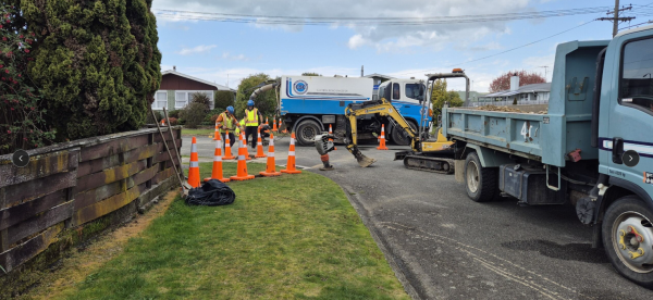
Wratt Street Overland flow path investigations at Woodlands Ave - Ground Penetrating Radar, potholing and coal tar sampling.
Contact:
Email [email protected] for further information, reference Project 1503.
The intersection upgrade on Whakarewa Street in the form of a roundabout near Manoy Street, is to provide safe access to and from the new Whakarewa Phase 1 Housing Development by Wakatu Inc, and the low impact roundabout design needs to cater for the safe egress of cyclists and pedestrians in all four directions.
The timeline for construction will align with provision of other services once design and consenting has progressed further.
Contact: Email [email protected], reference project 1342.
This project is to install a new reservoir to supply High Level Zone at Kaiteriteri above Honeymoon Bay.
|
Current status |
Planning |
|
Start Date |
TBC |
|
End date |
August 2025 |
|
Access |
N/A |
|
Contractors |
Not yet appointed |
|
Cost |
$TBC |
Contact: [email protected] for further information, reference 1277.
The project is to improve the flush to waste line, filtration and contact tank for the Kaiteriteri Water Treatment Plant. Part of this is to provide extra pumps to suit network pressure requirements and support needs in the community.
|
Current status |
Planning |
|
Start Date |
2025 |
|
End date |
June 2026 |
|
Access |
N/A |
|
Contractors |
Not yet appointed |
|
Cost |
$TBC |
Contact: Email [email protected] for further information, reference 1492.
This project is the development of a new Tapawera Community Hub. It will involve the combining of activities into a new fit for purpose building.
|
Current status |
Planning |
|
Start Date |
TBC |
|
End date |
Aiming for completed facility mid 2027 |
|
Access |
To be advised |
|
Contractors |
Not yet appointed |
|
Cost |
$TBC |
Contact: Email [email protected] for further information, reference 1531.
This project will install two new exterior bores and construct a replacement Water Treatment Plant building to improve the treatment process for water in Tapawera by upgrading systems that work to treat water using UV, chlorine, and filtration.
| Current status | In design and enabling works |
| Start Date | Drilling starts December 2024. Main construction start mid 2025 |
| End date | Construction late 2026 |
| Access | We’ll need some temporary traffic management on Tadmor Valley Road when we reach the construction stages but that should also be minimal. |
| Contractors | Not yet appointed |
| Cost | $TBC |
The bores will be drilled and developed, then pump tested and sampled over the next five months. Other work will then follow in mid-2025 to install the underground power supply components, before the building and internals are constructed in 2026.
The plant will be commissioned and online by Christmas 2026, then we can decommission the existing plant and bores on the other side of the road.
Having a resilient water supply that continues to meet national drinking water standards is the big driver of the initiative. The new plant will treat the water to a higher standard and be more reliable, but flow and pressure won’t change.
There should be little effect on the water supply during the life of the project, other than some short shutdowns when connecting the plant to the existing network and commissioning.
Contact: Email [email protected] for further information, reference 1494.
This project is to upgrade the Murchison Water Treatment Plant which includes allowing for redundancy for failure and replacement of deteriorated assets. It is one of several Water Treatment Plants we are upgrading in Tasman to provide clean water to local communities.
|
Current status |
Planning/ Design |
|
Start Date |
Construction start July 2026 |
|
End date |
Be completed mid 2027 |
|
Access |
To be advised |
|
Contractors |
Not yet appointed |
|
Cost |
$TBC |
Contact: Email [email protected] for further information, reference 1493.
This project is part of the upgrade being undertaken at Port Tarakohe Programme of work. This piece of construction is of an office and amenities block with a specialised marine waste management system.
|
Status |
In Contruction |
|
Start Date: |
October 2024 |
|
End Date: |
August 2025 |
|
Contractor/s: |
Coman Construction |
|
Cost: |
$1.6m |
Contact [email protected] for further information, reference 1424.
Why are we doing it?
This facility is designed to provide space for people who work in the commercial operations to work here and be a space for effective work and improve growth of this Port Tarakohe. It will also enable the users of the port to have new hygiene facilities and provide an office for the Tasman District Council staff to conduct their business.
The design
The concept design integrates both design influences from Māori lookout posts, Golden Bay cement history as well as embracing new technologies for a low-carbon and sustainable office design build. This office includes a room for commercial operators and amenities.
Office and Amenities Block Drawing Design
Update 2025 - Works Complete
Update May 2024
Work on the upgrade of Golden Bay’s Port Tarakohe is progressing well.
The more than $12 million dollar project has been made possible through a $6 million loan from Kanoa, the provincial development investment group within the Ministry of Business, Innovation and Employment, which is on top of the $6.7 million we have identified to invest in the 2024/2025 year.
A new fuel bowser has been moved to a new site at the end of the floating wharf making it easier and more convenient for vessels to refuel.
The new large berths are getting their finishing touches and the inner breakwater to offer increased wave protection has been completed.
Work on a new sheet pile wharf on the northeastern arm is underway and design work for new offices and an ablution block is being done.
Meanwhile, the long-term vision for the port is being developed with iwi, key stakeholders, recreational users, and the community to produce the Port Tarakohe Structure Plan.
Drafting of the plan is being done ahead of community engagement before the year’s end.
For more information on the Structure Plan, visit shape.tasman.govt.nz/port-tarakohe-structure-plan.
Port Tarakohe upgrade work started July 2023
This project comprises of three stages:
Stage One: Breakwater extension
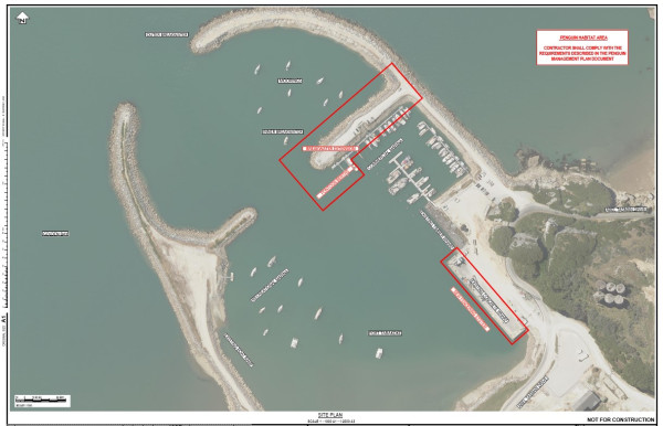
This includes a breakwater extension of about 20m, ending in a sheet piled wall. The existing breakwater of about 125m length will also be widened. These works include supplying new materials and reusing some of the existing ones. Since the breakwater and surrounding areas are Little Penguins Habitat, a major aspect of this Separable Portion is the compliance with the Penguin Management Plan. The successful Contractor will work closely with the Penguin Experts and Department of Conservation to ensure the safety of penguins during the works.
Stage Two: Fendering Upgrade
This work is to remove the existing worn-out fendering system on the concrete wharf and replace with a new sleeker design. This work will have to be completed at low tide and in good weather. The project involves removing some 60 piles; supply and installation of about 90 piles and new materials, and reuse of some of the existing materials where needed. The works will be completed in a way that allows 1/3 of the wharf to be always operational.
Stage Three: New Pontoons adjacent to new breakwater extension
New pontoon berths and new piles will be installed. These include removal of existing piles and plastic pontoons, driving several new piles, installation of concrete pontoons and an end wave barrier, and service pillars’ installation. The Contractor shall provide access to existing berths’ users during the duration of works.
We are upgrading three different Water Treatment Plant Filtration systems in Golden Bay (Collingwood, Pōhara and Upper Tākaka).
Works include:
| Current status | Delivery |
| Start Date | Construction Feb 2025 |
| End date | Construction end May 2026 |
| Access | N/A |
| Contractors | Process Flow |
| Cost | $309K |
Contact: Email [email protected] for further information, reference 1497/1571.
We are upgrading three different Water Treatment Plant Filtration systems in Golden Bay (Collingwood, Pōhara and Upper Tākaka).
This work includes:
| Current status | Delivery |
| Start Date | Construction early 2025 |
| End date | Construction end May 2026 |
| Access | N/A |
| Contractors | Process Flow |
| Cost | $629K |
Contact: Email [email protected] for further information, reference 1571/ 1491
We are upgrading three different Water Treatment Plant Filtration systems in Golden Bay (Collingwood, Pōhara and Upper Tākaka).
Works include:
| Current status | Delivery |
| Start Date | Construction Early 2025 |
| End date | Construction end May 2026 |
| Access | N/A |
| Contractors | Process Flow |
| Cost | $103K |
Contact: Email [email protected] for further information, reference 1498, 1587.
We have projects set up to look and improve these existing treatment plants to reduce impact on the environment and meet modern standards.
We are starting with Collingwood, Tākaka and Motueka and improving their Secondary Treatment Systems by investigating the work required and engaging special expertise.
We are looking at nutrient loading, decreasing solids and stormwater flows in all three plants, as well as reducing nitrogen and ammonia that is produced.
| Current status | In design |
| Start Date | Construction 2025 |
| End Date | Construction 2026 |
| Access | N/A |
| Contractors | Not yet appointed |
| Cost | $TBC |
Contact: Email [email protected] for further information, reference 1587/ 1451.
We're restarting work on a 1.3 km gravel/concrete shared pathway along the Moutere Highway, connecting the Upper Moutere shops to the Community Hall. This project, initiated by the Moutere Hills Residents Association mhra.org.nz, will provide a safe route for school children and a great option for visitors exploring the area by bike or foot. Thanks to local residents, Upper Moutere School, and the Moutere Hills Community Centre for their support.
Update March 2025
Project works starting in April in staged process. Works by our contractors be alongside the road, so traffic should be able to pass through the Moutere Highway as normal. There may be times when access to your property is interrupted for a few hours and there will be noise during the day.
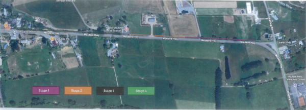
Stage 1 | Start of April - Mid May
Stage 2 | Mid May - Mid June
Stage 3 | Mid June - End of July
Stage 4 | August to October
View the map below or or open it in a new tab for larger version.
Update December 2024
Project on Hold: The Upper Moutere shared path has faced multiple delays since it was first proposed by the Moutere Hills Residents Association in 2008. The project stalled in 2021 due to unresolved landowner negotiations but was revived earlier this year. However, funding challenges arose when NZTA Waka Kotahi declined government funding for the project in September 2024, leaving Council to reconsider its options. On 24 October 2024, elected members decided against providing additional funding for 2024/25 to avoid rate and debt increases. The path is now set for completion in 2025/26, funded entirely by the Council over two years.
|
Current Status: |
Delivery |
|
Start Date: |
March 2025 |
|
End Date: |
June 2025 |
|
Access: |
The road will remain open and access will aways be given to affected residents. |
|
Contractor/s: |
Wenham Contracting |
|
Cost: |
$400,000 |
Contact: Email [email protected] reference 1557.
Map
Below is a map of the route of the pathway.
Upper Moutere Shared Pathway Route
View the full PDF version:
PROJECT COMPLETE Jan 2025
Moutere Hills Community Centre - Sewer System Upgrade
This project is the increasing the size and capacity of the existing wastewater system and disposal field at the Moutere Hills Community Centre.
| Start Date | Works start late September 2024 |
| End date | December 2024 |
| Access | N/A |
| Contractors | Hays Plumbing Services Ltd |
| Cost | $147K |
Email [email protected] for further information.
Update August 2024
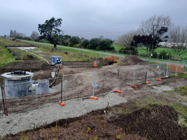
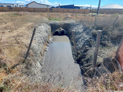
Our Gladstone-Poutama stormwater connection project is progressing, with photos below showing installation of a ‘Cascade gross pollutant trap’ and ‘Jellyfish storm filter’ out-letting into Poutama Creek. The Cascade trap works to remove hydrocarbons, litter and debris from stormwater runoff while the Jellyfish uses special filtration cartridges to further remove pollutants from entering waterways. We decided to implement both of these new engineering technologies in this project in Richmond to keep our waterways as clean as possible while being easy to maintain.
A gravel path that will double as maintenance access is included in the work to better connect Eton Street to the Railway Reserve. Photo below shows works update in August:
About the project
This project involves getting the pipe from Gladstone Road operational and improving the water quality of flows coming from the smaller stormwater pipe from the Poutama Street industrial area. The design seeks to minimise putting any assets into the outlet area as it is within the Hope Bypass Designation.
| Current status | In construction |
| Start Date | Underway |
| End date | Early October 2024 |
| Access | N/A |
| Contractors | Downer |
| Cost | $370K |
Contact
Project Manager: Giles Griffith
Email [email protected] for further information.
Complete March 2024
Earthworks to complete section B3 of the Borck Creek floodway north of Appleby Highway were completed ahead of programme this month.
We will be establishing vegetation over autumn/winter and installing a low flow bridge crossing to connect to paths on either side. Photos below show the recent completion.
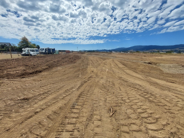
Borck Creek Floodway Feb 2024
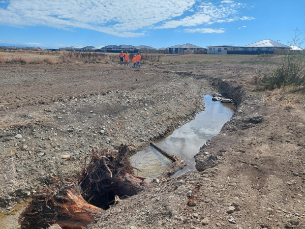
Low flow channel which has woody debris and steep sided pools excavated below the summer water table for fish refuge
December 2023 Update:
Construction of the upstream section of Borck creek will begin in January 2024.
This contract was awarded to Taylors Contracting.
The first stage of the work involves constructing a new private accessway as the creek excavation will remove an existing accessway. This will stop short of Appleby highway at the confluence with the new Eastern Hills Creek. Some gravel paths and a low flow bridge crossing the channel will also be constructed.
Winter planting will be undertaken following on from this work including downstream reaches of Borck Creek that require further planting
Borck Creek after the upgrade
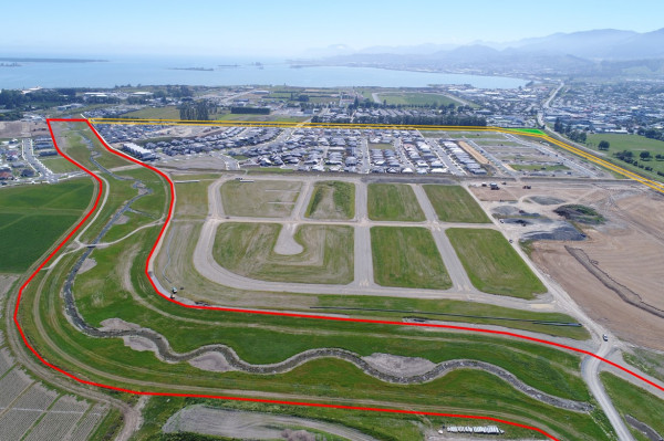
Overview of the site, Borck Creek shown in red and Poutama Stream shown in yellow.
Borck Creek and its tributaries, such as Poutama Stream, carry stormwater from the southern and western fringes of Richmond to the sea at Headingly Lane.
Development in both of these areas is putting greater demand on the channels and increasing the impact of flooding.
To minimise these effects, we’re upgrading both Borck Creek and Poutama Stream, by widening and deepening the channels. This will mean they can carry more water, which reduces the risk of flooding.
Construction and planting of the channels through the Richmond West development (Berryfields) is now complete.
Construction of the channel will progress upstream alongside development and the channel will be opened progressively as each stage of the new subdivisions are completed.
As part of the development of Borck Creek and Poutama Stream, we're building a new bridge to complete Berryfield Drive. The new bridge will connect The Meadows development on the McShane Road side of Borck Creek to The Fields/Applebyfields development, on the Richmond side.
This project is a long-term staged plan, which began in 2015.
During each stage of development, residents and people using the recreational areas next to the section being upgraded may experience some noise, dust, and vibration from the works.
|
Current status |
In construction. |
|
Start date |
2015 |
|
End date |
2027 |
|
Access |
Generally, access will be maintained, but areas under construction will be cordoned off. |
|
Contractors |
Various |
You can view images of how the completed project will look here (pdf, 3.7 MB).
The Landscape Plans are available in this memo (pdf, 4.2 MB).
The designs for the walkways currently under construction can be viewed and downloaded from the links below.
Contact us: [email protected]
Update July 2024 - COMPLETE
A key $4.5 million investment in improving stormwater resilience in part of Motueka is finished.
The Motueka West Stormwater Discharge Project involved constructing culverts to take stormwater underneath High Street, along Lowe Street, across Woodlands Avenue and through the Motueka Christian Fellowship property to Woodlands Drain.
Motueka West is planned to be the main new development area for the town.
The area encompasses 126 hectares of land bounded by Whakarewa Street to the north, High Street (SH60) to the east, King Edward Street to the south and Queen Victoria Street to the west.
Because it’s winter and temperatures are a bit colder, our contractor Fulton Hogan has left extra loose chip on Lowe Street to protect the new surface. While it will help the street in the long term, it means traffic will need to be a bit more cautious in the short term.
They’ll be out checking this occasionally over the coming months and will touch up any areas as needed.
Previous updates
The Motueka West stormwater discharge project is making significant progress, and the next milestone to be marked is the laying of pipes under State Highway 60 / High Street.
In the next phase of work, we intend to close a section of High Street at the Lowe Street intersection and the entrance to Wratt Street.
This work means we are going to have to close that section of the road for nearly two weeks from midnight Sunday 16 June until Thursday 27 June.
The work involves constructing culverts to take stormwater underneath High Street, along Lowe Street, across Woodlands Avenue and through the Motueka Christian Fellowship property to Woodlands Drain.
Motueka West is planned to be the main new development area for the town.
There will be significant detours in place while this phase of the project is done. All northbound traffic will detour via King Edward Street, Queen Victoria Street and along Whakarewa Street. Southbound traffic will be diverted along Tudor Street to Thorp Street and along Old Wharf Road.
Residents near the site will still have access to their properties, and pedestrians and cyclists can still move through the area with the help of traffic management staff.
All construction on site will be completed during daylight hours but the highway will remain closed for the duration of work.
Download the Antenno app on your smartphone to stay up to date with changes to traffic flows throughout the project.
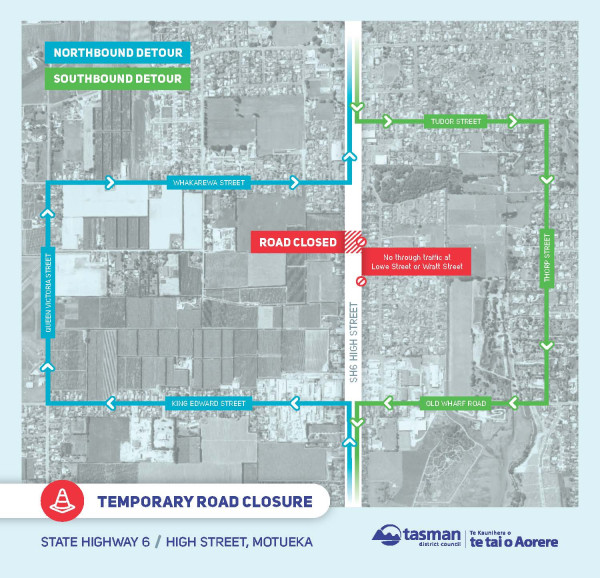
Update March 2024
Construction for the Motueka West Stormwater Discharge System project started this week at the Woodlands Creek end. The $4.5M contract will put in place multiple rows of stormwater pipes over a distance of 500m from Woodlands Creek, along Lowe Street and under High St into undeveloped land to the west. It will enable development of the first stage of Motueka West and will also alleviate localised flooding at High St and the Woodlands Ave/Lowe Street intersection.

Looking towards Woodlands Creek where the walking/cycle track has been diverted to enable the headworks to be installed

Temporary roadway built for the Church who's land the work has started in.
This project involves constructing culverts to take stormwater underneath High Street ( State Highway 60), along Lowe Street across Woodland Avenue and through the Motueka Christian Fellowship property to Woodlands Drain.
The purpose of this project is to provide additional stormwater capacity from the Motueka West Development Area* ( to the coastal marine area / Woodlands Creek. We’re investing about $4.5 million in improving this vital infrastructure.

The project involves undertaking improvements to drain stormwater west under High Street at the Wratt Street intersection. Shown on the picture above.
In the first six weeks or so of construction, our contractor is working within the church grounds before continuing across Woodlands Avenue, up Lowe Street and eventually across High Street.
The project is expected to take about six months, and there will be detours for traffic during some phases of construction.
Project Manager: Giles Griffith
Contact: [email protected]
*The area encompasses 126 hectares of land bounded by Whakarewa Street to the north, High Street (SH60) to the east, King Edward Street to the south and Queen Victoria Street to the west.
Update July 2024 - Works Complete
The Takaka Annex Internal refurbishment project is underway soon, and it will become a new Hydrology Satellite office for operations in Golden Bay. We also received approval to undertake an internal upgrade to set up the building with office with storage spaces and a lab area with an accessible toilet. We look to complete this June 2024.
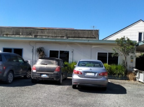
Takaka Annex Building
October 2024
The fences are down and we’re celebrating. The new Decks Reserve playground in Motueka will officially open with a special community ceremony on Friday 8 November.
The fabulous new development, worth close to $600,000, comes thanks to funding input from the Motueka Community Board.
There’s been a major redevelopment of existing play equipment, including the popular play tower, see-saw and space net, alongside the addition of numerous new play features.
There’s a new 3x3 basketball court, with soft rubberised matting around the play equipment and all manner of sensory and passive play elements, plus two new drinking fountains. There are now multiple swing sets including new basket net swings, accessible swings, and toddler swings, with a full revamp of concrete pathways, drainage, benches, seats, and landscaping.
The grand opening and ribbon cutting ceremony starts at 9.00 am on Friday 8 November and everyone’s invited to try out the new playground from 10.00 am.
Work begins August 2024
The new development for all ages comes thanks to funding input from the Motueka Community Board.
The total project, worth close to $600,000, will see a major redevelopment of the existing play equipment with the addition of numerous new play features.
The plans include a new 3x3 asphalt basketball court, and soft rubberised matting around play equipment with all manner of sensory and passive play elements. There will be multiple swing sets including new basket net swings, accessible swings, and toddler swings, along with a full revamp of concrete pathways, benches, seats and landscaping.
Some existing play equipment will be retained in the new layout, including the popular play tower, see-saw and space net. Read more about the plans.
The new Decks Reserve playground is expected to be ready to use by this summer.
Project Update July 2024
We invited our iwi partners to come along to the playground site and bless the project to begin works as well as share kai with members of the team. We have also awarded Nelmac the contract to work on the playground and work is set to begin end of July this year and due to be complete in September.
Decks Reserve Playground, Motueka
About the project
We’re redesigning and updating the current play space at Decks Reserve to improve accessibility for users in the community. This includes upgrading elements of the playground which are entering their expiration, as well as designing new aspects which cater to wider cross section of users including wheelchair friendly access.
Project Manager: Joe Bywater - Email [email protected]
The Māpua Streets for People project received government funding of $840,000 to shape the beginnings of a network of safe walking and cycling spaces in our streets.
Over the next two years, we will create and improve spaces for safer cycling on Aranui Road in Māpua, linking places where people live with schools, commercial centres and the wider existing network of cycle trails.
For more information on this project please visit: Streets for People | Shape Tasman
Work Complete June 2024
Work is nearing completion on the Motueka stopbanks refurbishment programme. Sites completed in the last six months include:
Debris that was deposited in the back channel from the Shaggery catchment during Cyclone Gita was also moved. This will improve flood resilience on Peach Island in a location where the stopbanks overtopped in July 2021. Localised repairs of weak spots on the stopbanks around Peach Island were also completed.
Once the overall work is complete, it will provide the area with a 1-in-50-year level of flood protection.
Funding of $10 million has been made available for refurbishment to improve their condition and provide additional climate change resilience. The project has received $7.5 million of funding from Kānoa – Regional Economic Development & Investment Unit. This funding contributes towards projects that build more resilient river communities.
Project Update December 2023
Phase 3: Work on emergency stop bank repair work next to the Horticulture Research Centre in Riwaka is nearing completion and is programmed to be completed in December 2023. Work at Peach Island is complete. Localised repairs at Hurley Bank are complete except for minor tidy up tasks. This project is majority funded by MBIE Covid Response Stimulus funding.


Phase 2: Complete except for minor finishing tasks.
Phase 3: Work on emergency stop bank repair work next to Horticulture Research Centre in Riwaka is approximately 50% complete and is programmed to be completed in October 2023. Work at Peach Island to complete localised repairs is continuing. Refurbishment and raising of 250m of stopbank at Peach Island, where overtopping occurred in 2021, has been completed. Localised repairs at Hurley Bank are in design. This project is majority funded by MBIE Covid Response Stimulus funding.
Motueka Stopbank Phase Two is nearing completion.
We’ve made some great progress on our Lower Motueka River stopbank refurbishment project, with four of the five sites essentially complete and providing over 3km of flood protection measures.
Phase One was completed in late 2021 and Phase Two started in March 2022. Phase Two involved work at River Road, Lyndhurst Drive, Parker Street and Douglas Road.
We have now reached the finishing stages of these locations, while work is progressing well on an extension of work at the end of Whakarewa Street.
The refurbishment improves the integrity of the stopbanks and provides safer access for ongoing maintenance.
Funding of $10 million has been made available for refurbishment to improve their condition and provide additional climate change resilience.
The project has received $7.5 million of funding from Kānoa – Regional Economic Development & Investment Unit. This funding contributes towards projects that build more resilient river communities.
Phase Three work is due to start soon at Peach Island and the Plant and Food Research Centre. We are also working with iwi to explore opportunities for environmental rejuvenation. All sites are scheduled for completion by the end of summer 2024.
We’re undertaking a programme of work on the Lower Motueka River stopbank network, to reduce the community’s risk of flooding from the river.
The current stopbank network was built in the 1950s and some areas have been worn away over time, or have settled, meaning they aren’t strong enough or high enough to provide the level of flood protection we need.
Generally, repair work will involve adding compacted earth-fill to sections of the existing stopbank that are too low or too weak. Repair work will happen in priority areas to resolve two types of issues:
There is a lot of work required, so the restoration is being staged over three summers between 2020 and 2024. Once the work is complete, it will provide the area with a 1-in-50-year level of flood protection.
We expect the cost of these measures will be $10M. Under the Central Government’s Covid-19 initiatives, we have received a $7.5M grant from the Ministry of Business, Innovation, and Employment's Provincial Development Unit towards that cost.
Stopbank sites under repair
The river itself won’t be affected, but if you use the riverbanks for recreation, you may find access to sections of the stopbank temporarily restricted or closed off, so check before you make any plans.
We are already in contact with landowners and occupiers of all affected land/riverbank areas.
|
Current status |
Phase One work completed. Development of the scope for Phase Three is being undertaken and work is expected to begin in early 2023. |
|
Start date |
February 2021 |
|
End date |
All sites will be complete by the end of summer 2024. |
|
Access |
Access to sections of the stopbank may be temporarily restricted or closed. Check if you are planning any recreational visits. |
|
Contractors |
Phase 2 Sites - Taylors Contracting Ltd |
|
Construction cost |
$8M (All sites) |
This map shows the area of works. See a larger version here.

Rob O'Grady, phone 03-543 8400 or email [email protected]
Phase 2 sites: Taylors Contracting Ltd - Brendon Dodd, phone 027-422 2059
The Richmond Streets for People project received Government Funding of $2.4 million to shape the beginnings of a network of safe walking and cycling spaces in our streets.
Over the next two years, we will create and improve spaces for safer cycling on Salisbury Road, Wensley Road, Queen Street, Hill Street and Champion Road, linking places where people live with schools, commercial centres and the wider existing network of cycle trails.
For more information please visit: Streets for People | Shape Tasman
Last modified: