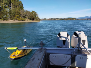
In a great collaboration between our Harbourmaster, Environmental Monitoring and Natural Hazards teams, we have recently completed bathymetric mapping of sub-tidal channels in parts of the Waimea and Moutere inlets.
It’s a tricky word to pronounce, but in simple terms, bathymetry is the study of the underwater depth of ocean, lake or river floors....and in this case, estuaries.
The accurate mapping of these channels is a key requirement of a wave modelling project being run by the National Institute of Water and Atmospheric Research (NIWA) with Envirolink funding for the natural hazards team.
This will help provide improved information about coastal inundation processes around the margins of the two estuaries. It will also be of value to the Harbourmaster team’s efforts to ensure navigational safety.
While we have Light Detection and Ranging (LiDAR) surveys of the estuaries, the LiDAR surveys are not able to penetrate water so do not capture the morphology of sub-tidal channels – this new mapping completes the coverage of the estuaries in these sub-tidal areas.
This work was also carried out with the help of Nelson City Council’s hydrology team, who lent the team a ‘SurfBee’ autonomous surface vessel (USV) for the surveying.
Waimea Inlet (3462ha) and Moutere Inlet (764 ha) are shallow, well-flushed tidal lagoons that discharge to Tasman Bay. Both have high ecological values, as valuable nursery areas for marine and freshwater fish, shellfish beds, as well as being very important for birdlife.
Because of this, both inlets are subject to ongoing monitoring programmes to ensure they stay healthy for many years to come.


